Although a little unsure of reaching Incahuasi Island, heading out from Uyuni felt good. My plan was to firstly ride to the village of Colchani that we'd visited in the 4x4 just before riding onto the salt flat.
Although only twenty two kilometres away a wind that gained in strength as it blew across the vast salt flat hampered my progress but I wasn't too bothered as I knew the village hardly had much to do once I did arrive.
Finally arriving at the village I'm greeted by several pigs trotting across the gravel side-road. Without the hordes of 4x4's parked-up, derelict is a word the springs to mind. A sorry looking place that looked as fun-filled as a shopping centre. Nevertheless the salt was not far away, it felt so different being here with my bike, no longer cocooned in the safe environment of a vehicle, fingers crossed the wind would ease up for the following day ridin' the salt.
The hospedaje (hostal) had just a few rooms, each just big enough to fit a double bed within but was good to be out of the wind. The place also doubled-up as a tourist stop-point for the organised trips similar to what I'd done and within the front entrance area was several salt-block tables and chairs where tourists would eat their included meals.
Like one of the old trucks along U.S. Route 66.
Although a relatively dry area the salt bricks do eventually start to weather-away, this shows what almost looks like mortar seeping out.
In the evening I walk around the town in search of food and to the railway 'station', see the altitude?
Arriving back at the hospedaje a couple of Canadian cyclists had arrived from Uyuni. Strangely they planned to avoid Incahuasi Island, instead ride north-west across the salt flat to the northerly Volcano Tunupa....different horses, different courses.
Packed up and off the next morning I slowly bob down the corrugated gravel route that leads to the salt flat, the sky was clear and not the slightest of breeze, fingers crossed it would stay that way.
Upon reaching the salt I pinched myself at being there, just me and my bike on the edge of this vast open salt desert. Standing 1800 metres higher than the salt I could see the northerly volcano, it gave reassurance that if should I get lost I could always head for it..although it would still be many hours to reach.
Tyre tracks here-n-there all lead west so I started following them, I could make out the hotel that sits 7km in so firstly aimed for that.
Next to the hotel is a salt monument for a rather well know rally. Initially from Paris to Senegal's capital - Dakar, in 2008 Mauritanian security threats saw it changed to South America.
On the 4x4 tour we'd stopped at the neighbouring hotel for our first lunch, a basic building that I could have easily reached the day before but - being on the salt flat - prices are extortionate!
After an hour of riding I was still slightly unsure / worried about actually finding the island, but optimism overriding pessimism I carry on. By now the hotel [behind me] had become a mere dot, distant 4x4's speeding along, a few pass close-by tooting their horn. In the westerly distance I see a dark tiny dot (middle of the photo), presumably another car.....a while later it's not moved, a buzz of excitement tells me it must be the island, continuing forward its size hasn't changed, just a small dot.
An hour later it's become a tad bigger, but now I have a small grey cloud of doubt over it being the correct island as there's a few and only the main one will have water. Slowly, slowly it gets bigger, very slolwy! Another hour later and it's looking good, but from here it still took another hour to reach, soon I'm 100% sure as I could see some of the cactus, like small hairs protruding from all over it, the distance covered was seventy six flat, white, kilometres.
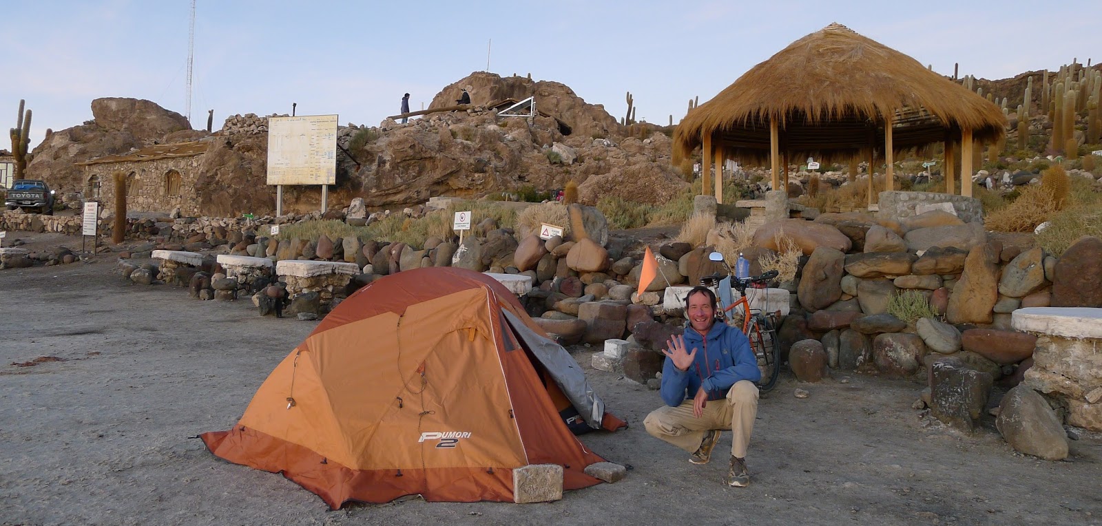
Feeling proud / thankful that I'd reached it I sit and once again marvel at the place. I'd first read about it in some of the touring books I'd read so to now be here under my own steam was even better than my initial visit. Thankfully the day's weather had stayed wind free making a matching compliment to the perfect scenery.
As before, the place was packed with 4x4's so with still too many people around to comfortably set camp I firstly cook dinner, having running water in such a remote place made it easy, also meaning I only needed to carry a few litres for the day's ride. As the day starts closing-in the 4x4's start to leave giving me the space needed to set my tent.
I new it would get cold that night so I slept in my clothes and with just my head sticking out my sleeping bag around 4 in the morning my head felt it so had to put my woolly hat on! bbbrrrggggg! An hour later and the 4x4's start to return bringing tourists to see the Sun rise from atop the Island.
Tahua - the village sitting at the foot of Volcano Tunupa just on the edge of the salt flat was about thirty kilometres away. Initially a cold start but slowly the temperature increased - being at such an altitude the Sun's heat doesn't take so long to be felt as the thin air warms so much quicker ( the same in reverse when the Sun drops, the temperature quickly dropping).
Albeit a gravel road at the village, it was good to get off the whiteness of the salt-flat and onto the darker easier on the eyes trail. Snaking around the foot of the mountain I amble along and upon reaching the village Jirira decide to stop there.
The following day firstly started with several kilometers of walking up the dusty gravel route, passing through deserted looking villages, still questioning why anyone would want to live here, maybe the locals questioned why anyone would want to ride here.
Later the route led back down toward salt's edge and a strong wind saw me walking, several vehicle tracks in the dirt-brown salt led in various directions causing slight uncertainty of the correct way but head toward a village I could faintly make out, an hour or more later I flag a passing truck and am informed I was heading in the wrong direction! Now heading with the wind I'm contently back on the saddle. Even on the salt's edge with it being so flat and open distances are so difficult to gauge but by late afternoon I reach the town of Salinaz de Mendoza, my legs aching from half the day's walking.
The following day in contrast to what the map showed I was pleasantly surprised to see the tarmac commenced at the town's edge. Four days later after a couple of fifty kilometre pick-up truck rides and my first coach ride I arrive at the country's capital - La Paz. The day after I arrived was my mother's birthday, wanting to ensure I could contact her being the main reason for the coach ride.
With a Warmshower host arranged in the city we meet the following morning for breakfast. Rodrigo's family owned a hostel and I was given space in a disused room to make camp. To be honest this was a strange one as apart from occasionally seeing Rodrigo here n there there was no real contact, being in a hostel meant I could talk to the many other travellers but not really so with the host.
La Paz is a huge city that's situated in a basin-like area between the surrounding mountains. With major traffic issues several years ago three big ski-like cable car systems were installed to ease the problem, these give a great view of the city - nice and quiet away from the continual tooting of horns and [almost] daily demonstrations from people opposing some latest government plan.
It also proved an ideal place to get repairs done. Some of my pannier bags needed the broken plastic buckles replacing along with sewing to a few items, one street was jam-packed with such stockists and repair shops. My rear wheel also needed truing. One of the areas main tourist attractions is 'The Death Road' of which 'Gravity Cycles' is the largest operator so as such have a large bicycle workshop, locating it okay the following day I return to a nicely trued wheel.
Immediately noticeable with Bolivian ladies (Cholitas) are their bowler hats. The history behind the hats goes like this; Back in Manchester, shortly after the bowler hats were invented, two brothers were manufacturing a line of bowler hats. Their plan was to sell them to the British railway workers who were working in Bolivia at the time.
However, when the hats arrived to South America they found that they were way too small to fit the heads of the men. So, instead of throwing them out they decided to create a “fictional” story to tell the Bolivian Cholitas. This story was that all the fashionable women in Europe were going around wearing these bowler hats and it was the new fashion trend!..the rest is history.
The weather had turned cold and wet, I was waiting for some clear skies to ride the Death Road. The sixty four kilometre road's on the side of a very high shear-drop cliff edge that had seen (before the new road was built) many vehicles go over the edge. Booking a ride I hoped the sky would be clear.
The day of the ride saw our minibus wait for an hour or so before the night's snow on the road further up the mountain had cleared. When we finally reach the point where we start cycling the bikes are unloaded from the roof-rack as we don ourselves in the body armour and full-face helmet. Initially we'd ride fifteen kilometres of tarmac on a descent before re-loading the bikes to reach the start of the Death Road itself. The air was heavy and damp, thick clouds lurking low, the road drenched from snow melt, quite cold at times!
Eventually we reach the infamous route and start our descent, rough as hell, bumpy, bashing over the route on bikes that had well ad truly seen better days!
As shame about the clouds as they prevented us seeing the sheer drop we'd been riding against. The route drops from 3500 to ~ 1700 metres over its length and later on we were soon stopping to remove layers of clothing. So much for our guide keeping an eye on us escorting us along, he'd buggered off down the mountain!!...not that I was bothered, the route is hardly dangerous for bicycles..unless your front wheel or forks breaks!
At the bottom the bikes are re-loaded and we make our way to a hotel for the included meal. Driving back to La Paz took several hours, our small group felt quite achy from the day's rough old route!
Having felt I'd now spent long enough in Bolivia, and far too long in La Paz I really wanted to reach Peru so decided to exit the city the same way I'd entered....by coach!..hopefully this wouldn't become too much of a habit but the high-altitude cycling easily swayed my decision! With bike and bags safely stowed i'm comfortably seated as I head to the Bolivia / Peru border town of Copacabana.
Once La Paz was out of view the road opened out into some pleasant scenery, from behind the coach's window the clear blue sky looked inviting but the distant snow-caped peaks didn't quite convince me.
Copacabana sits on the eastern shore of the world's highest lake, Lake Titicaca, perched at 3800 metres (12,467 feet) and to reach the town we had to disembark the coach for a brief ferry crossing over a small section of water by a pretty little village.
So next up, I finally reach Peru where I
get to see one the Wonders of the World
- - -